Tuesday, December 28, 2010

Mt. Adams, December 23rd

A couple days before Christmas, RD and I made an attempt at Adams. Up at 6 in North Conway, with lunch and gear packed the night before, we were on the mountain by 7:30, so we had plenty of daylight to play with. But going was slow. Even the Appalachia parking lot had gotten a couple of inches of snow during the night, and the higher up we went, the more accumulation we encountered.

Elevation seems to influence weather even more during the winter than in summer. The hike up the Airline takes far longer in the winter than summer, inducing you to study the forest in somewhat frustrating detail. The whole time we had a pretty good idea of how far it was to treeline simply by the temperature. When we needed our hats, we knew we were about to pop out.

When we did emerge onto the ridge, visibility was limited, and snowdrifts began to seriously impede our progress. It probably took us an hour to get from treeline to the Airline Cutoff—a distance that only takes fifteen minutes to cover in the summer. Our snowshoes helped with the snow, but the pitch of the slope made us slide back, sometimes three or four steps in a row. The quads and hip flexors felt this part of the hike.


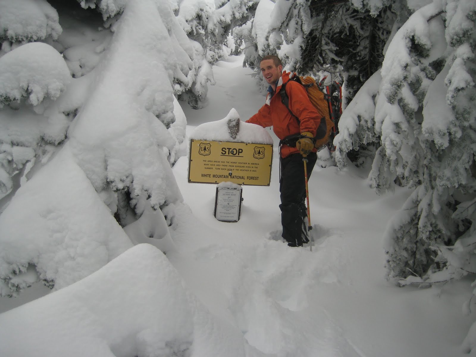
Unfortunately, the clouds never lifted as the weather report had suggested, so we never got to look across King Ravine. However, the rime ice on this trail sign was superb.

Past the Airline Cutoff, the wind increased sharply as we rose above Adams’ western ramparts. This made the going much easier because the snow was scoured from the mountainside, allowing the teeth of our snowshoes to bite into the granular snow, but of course the air grew a great deal colder, too. At the junction of the Airline and Gulfside Trails, we paused for a picture, a bite to eat, and a powwow about whether to continue.

Given the limited visibility and the difficulty of distinguishing cairns, which had become white lumps of rime by this point, we decided to forego a summit attempt and instead descended along the Gulfside to Madison Hut, which was rebuilt by the AMC’s construction crew during the late fall. It was a chilly walk downhill made eerie by the strange sensation of recognizing landscape features that, given the snow and ice, seemed very out of context. I was glad we did not continue up the summit cone, which I do not know so well as this section of the Gulfside.

The new Madison Hut, which CC was working on until Thanksgiving, looks snug and very similar to its predecessor (this photo shows the old bunkrooms, of which the skeleton has been preserved because it dates back to the thirties). The interior is apparently different, but since the hut was boarded up for the winter, reviews will have to wait until next summer. Not yet ready to head down the Valley Way, we trekked up to Star Lake and found the moon rocks, though the white quartz was concealed by a layer of ice.

The wind was fairly cutting here, too, so we turned around and sped past the hut onto the powdery length of the Valley Way. The snow was so deep that we could slide down the steeper patches at a great pace. Before long, we were exhausted, however, and the bottom half was a drudge. We were off the mountain at two, without having seen a soul the entire time.

Monday, December 20, 2010

The Food-Safety Bill Squeaks Through

Lost in the turmoil over the DREAM Act and DADT, the tax compromise and debate over ratifying the START Treaty, the food-safety bill passed the Senate last night by unanimous consent. Given that it only takes an objection by one Senator to slow down the voting process by several days, and the bill had previously received 25 no votes, its easy passage was an enormous surprise. What happened?

The food-safety bill has been rattling around the Capitol since the early on in the 111th Congress, but despite prompt action by the House, the Senate, in keeping with its “deliberative” nature, dragged its feet. The bill would give the FDA substantially increased regulatory powers and $1.4 billion to hire thousands of new food inspectors, among other things, but it faced considerable opposition. In particular, small producers rose up en masse because the House version would have compelled them to pay substantial inspection fees and achieve the same standards for cleanliness as large producers, which would be both impractical and pointless. (A farmer who slaughters a few of his own grass-fed cattle doesn’t encounter the same issues as corporate operations that process thousands of animals a day in one abattoir.)

In any case, thanks to Jon Tester, Senator from Montana and a former organic wheat farmer, the Senate bill made an exception for “family-scale” operations (note the usual ridiculous conflation of domesticity and agriculture)—farms with annual sales under $500,000. The bill passed the Senate shortly thereafter by a vote of 73-25. While some have called it bipartisan, and it did pick up the support of a number of Republicans, the bill’s supporters were overwhelmingly Democratic.

It appeared, then, that the House needed only to pass its own version of the Senate bill (the language of the two bills must match or else representatives from both houses must reconcile the differences between the chambers, necessitating another vote on the final product) for the bill to advance to Obama’s desk. But then, appallingly, someone discovered that the Senate bill included revenue raising measures that, as directed in the Constitution itself, must originate in the House of Representatives. So the Senate’s efforts were all for naught, and a new bill needed to be advanced. With time short, and other, higher profile bills awaiting consideration, it did not appear that the bill would again be brought up. With Republicans taking over the House next year, this would have likely been the last of the food-safety bill.

The bill’s particular foe was Tom Coburn, an Oklahoma Republican who is particularly conservative and rather more ideologically consistent than most of his caucus. He objected to the increase in power for the executive branch through the assumption of new regulatory powers, preferring instead to rely on the power of the market to encourage voluntary self-regulation (not so popular with those who caught salmonella last summer). Joined by a coalition of corporate lackeys (wonder which party will receive more donations from agribusiness this year?) and the ignorant (some observers simply refuse to acknowledge the Tester exemption and treat this bill as the death knell for localism), Coburn stood ready to gum up the Senate if Harry Reid scheduled another vote on the Food-safety bill.

Until last night. Despite overwhelmingly negative predictions by the few observers in the press followed the story, Reid managed to pass the food-safety bill by unanimous consent. Evidently, the dogged Oklahoman blinked. What little has been reported about the bill’s success fails to explain why he stood down, but my guess is that the Senator feared making a futile gesture that would keep the Senate in session through Christmas day. The bill clearly had the votes to pass, and Coburn would have enraged the other Senators if he kept them in DC much longer. Thus, if my hypothesis is correct, this is one of the few times when Democrats have successfully manipulated their opponents into surrender. Hurray for Harry Reid—his recent re-election seems to have been cathartic, if the lame duck session is anything to go by.

The food-safety bill now heads to the House, which will need to vote on it once more before it reaches Obama. Without no filibuster available to the House GOP, its passage is assured, so Obama will sign it shortly. It should be a great relief to food consumers (everybody) that FDA will now be able to force companies to recall most tainted food (not meat, however). We shall have to see how vigorously Republican presidents fulfill the new mandate before rendering final judgment. However, as discouraging as the past couple months have been politically, passing the food-safety bill is a major achievement, and for all the problems with the Democratic leadership, they deserve a great deal of credit on this front.

I took the picture at the top during the summer of 2004, driving through the Palouse region of southeastern Washington State.

Thursday, December 16, 2010

Nearing Solstice

My apartment was suffused with light this morning. Evidently, there is something to be said for rising in the dark.

The steam is coming from the Lamont Street Lofts, which were originally the Arcade-Sunshine Company, a rare example of industry (laundry and dyeing) in the District.


And again, on the morning of the seventeenth. I got up early to bake some gingerbread (last day of classes before winter break) and was wide awake for the entire symphony. Milo in the Phantom Tollbooth never had it so good.

There is nothing like watching a series of sunrises or sunsets for developing a sense of place, but what with schedule and blocked horizons, it's rare to get an unobscured view of one in the metropolis.

Wednesday, October 20, 2010

Sunday on Lafayette

RD and I spent two nights at Greenleaf, visiting Ari Ofsevit, an old friend of mine from college. The fall I worked at Mizpah, Ari was finishing the AT (it made a good topic for our alumni magazine, as it turned out), and he visited me at Galehead and Zealand a number of times. Finally, he could resist applying to work in the hut no longer, and he took a job as naturalist at Madison last summer. I've been eyeing the slides on the east side of Lafayette, which extend far down into the valley shared with Owl's Head, for several years, and our plan on Sunday was to circle around via the Franconia Brook Trail and hike the slides from the bottom.

At night, the temperature dipped into the teens, making for a substantial amount of frost and rime above treeline. Given the conditions, we decided it would be better to stay in the hut and stuff ourselves with bacon for most of the morning, but we did eventually head up to the ridge once the day warmed up. Here is one of the croo members, Laura, on the upper section of the Lafayette summit cone.

Mike, the assmaster, with Cannon cliffs and Lonesome Lake in the background. Laura was off to Galehead for days off, so for the rest of the afternoon it was the four guys. We spent a long time on the summit working on our Boston accents.

Though the slides were out of reach, there is a bare spur on the east side of Truman, the satellite peak between Lafayette and Lincoln, that exerted a pull. I was intrigued by the novel perspective on the Pemigewasset, not to mention the view back toward the slides and Franconia Ridge.

The going wasn't too bad, but there were a few patches of krummholz that wouldn't give in easily.

The view back toward the ridge.

Having a rest on the spur. It was a spectacular fall day, with plenty of warm fall sunshine that felt delicious in the crisp air.

A closeup of the cliffs on Garfield from a new point of view.

A look back at the Lafayette slides.

South across the eastern ridges of Liberty and Flume.

Looking across Owl's Head to Bondcliff.

Back up on the ridge, looking across the ridge that Greenleaf straddles, into the north country.

Now headed back down to the hut to get ready for dinner.

Dusk at croo rocks.

Sunday, October 17, 2010

Norcross to Greenleaf

From Norcross Pond, RD and I descended back down the Nancy Pond Trail, and from there, we drove to the base of the Old Bridle Path. We made it up to the hut just before Go Time, five o'clock, which is when hut croos start getting ready for dinner. This post is nothing more than a gratuitous display of some pictures I took along the way and outside the hut during dinner.


Nancy Cascades, unusually high in volume for this time of year.

Not too far from the Long Walk campsite.

Up on Agony Ridge, now, looking south along I-93.

Looking down at Profile Lake.

Mr. Jenkinson, snapping away. He likes the color orange.

Camel's Hump, off in Vermont.

Cannon Mountain. The buildings are the top of the tram.

Thursday, October 14, 2010

Beaver at Norcross Pond

Over the Columbus Day weekend, I flew up to New Hampshire, while my old pal from the huts, RD Jenkinson, drove over from Middlebury to meet me at the Manchester airport. RD and I worked at Mizpah (the Black Pah) in the fall of 2006, when we bonded over dressing up in drag to entertain hut guests and traversing the Presidentials at night to raid Madison and Lakes.

RD’s family recently bought a house up in North Conway, so we spent our first night there rather than hike up in the dark to Greenleaf, where we were meeting another friend of mine who has appeared in these annals. As we had some time to play with on Saturday morning, we hiked up the Nancy Pond Trail to Norcross Pond, which sits on a plateau between Mounts Nancy and Anderson at the eastern edge of the Pemigewasset Wilderness.

The Nancy Pond Trail was first cleared in 1938—the year of the Hurricane of ’38. Little of the trail remained in the wake of the storm. The next year, the Lucy family built a mill about halfway up to Nancy Cascades to salvage some of the downed timber, but little else happened along the old path until the sixties, when Camp Pasquaney, thanks to an extraordinarily energetic and hard-working counselor named Dave Ryder, reopened the old trail. He still works at camp, running the wood shop. When I was a camper, he was known for demonstrating the sharpness of an ax by using it to shave his arm hair.

I attended Pasquaney for five summers as a camper and returned for another five as a counselor. During seven of those summers, I spent five days in early July on ten man expeditions doing trail maintenance along the Nancy Pond Trail. Often we would camp by Norcross Pond, which empties to the west, into the Pemigewasset watershed. The stream has scoured a series of rock ledges, which are a good place to drop one’s pack and gaze west at the Bond Range. It is an ideal place to cook and sit around with your group.

One year, when I was leading an expedition in the region for the first time with an older counselor named Trey Winstead, one of the boys, a thirteen year old who was particularly energetic and mischievous, grabbed a grub hoe and ran off to dig in the mud holding back the pond behind us. Trey and I exchanged glances, relieved to have the boy occupied while dinner cooked. A few minutes later, however, a sheet of water washed over the ledges where we sat, and it did not abate. Luckily, the camper was able to put things back to right, but the pond had lost a couple of inches.

More recently, beavers recolonized Norcross Pond, for the first time, I believe, in camp memory. The lake now sits several feet higher than it used to, and much of the old trail that ran around the lake is now submerged. Last year, the Forest Service, assisted by Pasquaney, rerouted the trail to higher ground and installed dozens of new bog bridges. In the old days, camp might have handled all the work itself, but I am glad that we are now focusing on what we can do best (keeping the trail clear), leaving the heavy work to professionals.


Our hike was on a cool, crisp day—the best of New England fall. By the edge of the pond, the wind was swift and steady, forcing us to seek shelter in the forest while we ate lunch. In addition to the dam, the beavers have constructed a substantial lodge on the north side of the pond. Like the dam, it looks solid and well maintained.

Beavers have been on the move all over the Whites recently. I believe they have resumed activities in the Zealand Valley since I worked at the hut in 2008, causing some flooding to the trail there, too. Alex MacPhail included a photo on his blog not long ago of a metal pipe someone had stuck through a dam to improve drainage. When I was the naturalist at Zealand, I gave a program, usually to younger visitors, called “Our friend, the beaver,” for which I learned that beavers, despite their reputation, don’t actually work all that long during the day. They are incredibly energetic during those hours that they are active, however. Apparently the sound of water stimulates their dam-building acumen. That pipe won’t be effective for long.

A few summers ago, a beaver turned up in the vicinity of Lakes of the Clouds Hut, no doubt having climbed up Ammonoosuc Ravine. It must have disappointed to find no trees to fell across the outlet of either lake, and I am curious where this singularly persevering rodent waddled off to when it left.

In celebration of this resilient beast, then, nearly hunted to extinction for its pelt, I offer a song that I learned while working at the W. Alton Jones Field School:

Beaver one, beaver all,
Let’s all do the beaver crawl!

Cha-cha-cha, cha-cha-cha,
Cha-cha-cha, cha-cha-cha.

Beaver two, beaver three,
Let’s all climb the beaver tree!

Cha-cha-cha, cha-cha-cha,
Cha-cha-cha, cha-cha-cha.

Beaver four, beaver five,
Let’s all do the beaver jive!

Cha-cha-cha, cha-cha-cha,
Cha-cha-cha, cha-cha-cha.

Beaver six, beaver seven,
Let’s all go to beaver heaven!

Cha-cha-cha, cha-cha-cha,
Cha-cha-cha, cha-cha-cha.

Beaver eight, beaver nine,
Stop! It’s beaver time!

Go beaver! Go beaver! Go Beaver!

Tuesday, September 28, 2010

Wild and Wonderful

Last weekend, Will Kryder and I drove out to Dolly Sods, lured by a description in Backpacker Magazine that mentioned "harsh winds, bogs, stunted spruce, and snowshoe hare." In short, it sounded a bit like New England's north country, though the region is actually part of the Monongahela National Forest, which covers much of the rugged Allegheny Mountains. The drive out was long, over three hours, but it was beautiful traversing the valleys of eastern West Virginia. They are mostly too uneven for mechanized row cropping, so cattle and chicken farming are fairly common.

The hike did not disappoint. I've never walked across anything quite like this undulating, tundra-esque landscape. We spent most of the day in the open, striding through expanses of heath dotted with trees. The trail also plunged into dense thickets of conifers and a copse or two of deciduous trees in the midst of succumbing to autumn.

The evergreens peering over the grass give this picture a sinister aspect, particularly because the grasses are bending away from the trees, toward the camera. The weather was grey and windy, with a consistent speckling of raindrops, though the storms mostly held off. The landscape felt desolate and isolated, as a far corner of the Arctic might while preparing for winter.

Washington has been unbearably hot of late, but at 3,500 to 4,000 feet, the elevations at which our hike took place, the vegetation was faded and colorful. Imminent death hung over the landscape.

The region also has some notable outcrops of limestone, which have weathered into some bizarre formations. In the distance in above picture is Blackbird Knob.

In the spring, Dolly Sods must have a vastly different mood. We spent much of the day hiking along Raven Ridge but didn't catch a glimpse of the bird. I'll look for them when I'm back, hopefully after next winter.

The plateau was once covered by a vast forest of Red Spruce, which was reported to be the largest stand of its kind in the world. Wikipedia tells me that the trees grew as tall as ninety feet, with diameters up to twelve feet! Once the railroad penetrated the region, however, the forest was doomed, and with the trees gone, the soil dried up and blew away. Sparks from steam locomotives soon ignited slash left behind by the logging, and the trees still haven't come back, though the ecology became ideal for blueberry and huckleberry bushes. Their scent was distinctly in the air on Sunday. The region gets its name from the Dahle family, who cleared the land of logging debris so that they could sheep along the new pastureland.

The local ecology now, like the alpine areas of New England, has much in common with the Canadian tundra. In short, it feels familiar, and though a bit of a push for a day hike, should make for a good overnight in the future.