Saturday, April 28, 2007

The abandoned Adams Slide Trail

Oddly, given the emphasis on exposure and challenge in today’s world of outdoor sports, New England’s steepest hiking path no longer exists. The Adams Slide Trail, last included in the White Mountain Guide in 1967, ascended 2300 feet over 1.25 miles.

The Adams Slide Trail went extinct around the time that the backpacking boom was taking off. Its isolation, deep within the Great Gulf Wilderness (and invisible except from Mts. Washington and Clay), kept traffic minimal, in stark contrast to Tuckerman and Huntington Ravine Trails on the east side of Washington. It was too steep for any but the most experienced to use on a serious backpacking trip.

The trail was always difficult to maintain, right back to its cutting in 1909 by Warren Hart. Unlike the better-known J. Rayner Edmands, whose gradual, winding paths were a testament to his belief that hiking should be a civilized endeavor, Hart sought the summit by the quickest means possible. In some places, the Adams Slide Trail climbs at 45 degrees. Rockfalls inevitably took a heavy toll.

The Adams Slide Trail is only one of several trails Hart built in the Great Gulf. Indeed, during that summer of 1909, another of his crews completed the Six Husbands Trail, named for an apparently insatiable Indian Princess. Ascending a rare (for the Whites) arete—one of Mt. Jefferson “knees,”—the Six Husbands Trails is one of the steepest, wildest, and most beautiful trails in the northeast. Like the other evocatively named trails Hart built in this giant glacial valley—the Sphinx, Buttress, and Wamsutta (one of the six husbands) Trails—the Six Husbands Trail feeds into the region’s hiking thoroughfare, the Great Gulf Trail, which itself makes a long and exposed climb up the Great Gulf’s headwall.

Since the AMC stopped maintenance, a trickle of hikers have continued to use the Adams Slide Trail, drawn by its steepness and historical interest. While blowdowns and thickets are major obstacles, particularly near the lower junction with the Buttress Trail, old red paint blazes are still visible below treeline. A surprising number of cairns still stand in the alpine tundra, marking the way up over Mt. John Quincy Adams before petering out just before the true summit.

Now that the Great Gulf is officially wilderness, the chances of the Adams Slide Trail reopening are nil. But that’s probably for the best—it’s good to have challenges like this when the beaten paths become a bit too familiar.

Photos: The Northern Presidentials - Adams is in the sun, with the slide directly below the summit but down about one thousand feet; Looking up at Jefferson’s Knee from the Great Gulf Trail.

Saturday, April 21, 2007

Devil's Tower

If there's anything to make me want to rock climb, this is it.

Devil's Tower rises up out of the plains in northeastern Wyoming. I visited it on my way back from Elk Creek Gardens in Oregon to St. Paul at the end of summer in 2004.

Devil's Tower is an igneous intrusion; i.e. a very resistant piece of volcanic rock called porphyry that forms hexagonal columns as it cools. The surrounding rocks are sedimentary, making them far less resistant to erosion. Originally, they probably surrounded Devil's Tower but have gradually worn away, while the harder igneous rock remains solid.

New England doesn't have anything nearly as dramatic as Devil's Tower, but the Appalachians are made of granite, another durable igneous rock, which is why they are still around after so many ice ages.

Sunday, April 15, 2007

An alarming link

Though many of my friends find my stubborness to get a cell phone infuriating, I still rely on a landline for a number of reasons: it's simpler and less consumptive, the situations when a portable phone would be useful are, for me, rare, in many places where I've worked, there's no service (in fact, I often like being unreachable), and I loathe the culture that has grown up around cell phones (like IMing) - people compulsively needing communication, though it is frequently devoid of meaning and obscures how isolated people in our society truly are.

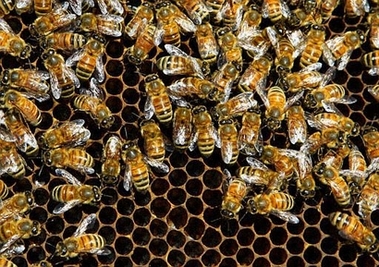
Now, German researchers are linking radiation from cell phones to the massive disappearance of bees in the United States and Europe, which first occurred last fall. The theory proposes that the radiation from the phones disrupts bees' ability to navigate, preventing them from returning to their hive and dying of exposure.

http://news.independent.co.uk/environment/wildlife/article2449968.ece

If bees are unable to recover from their affliction, agriculture faces a mammoth challenge. How can plants reproduce without bees to carry their pollen? The worst-case scenario is not pleasant.

I wonder whether bees are dying in developing countries? Since far fewer people own cell phones (though numbers are on the rise) in the Global South, bees should be doing better there.

If bees are the canary in the coal mine regarding cell phones, their situation is similar to that of the frog species and other amphibians which have been dying off in massive numbers over the past decade. While they provide no immediate use to mankind (except perhaps to the French!), frogs are understandably sensitive to changes in water quality. While evidence is not conclusive (in part because their demise has been so general), it seems logical that they are responding to changes in water quality, not necessarily immediately fatal to them but enabling other species, viral or bacterial, to gain an adaptive advantage, upsetting the balance within aquatic ecosystems in both both hemisperes.

A final point: studies showing a connection between cell phone use and brain tumors are, as yet, inconclusive, though there has been evidence of correlation (see the article in the Independent for details). However, I am wary to put chemicals such as lead, beryllium, arsenic, mercury, antimony, and cadmium near MY head.

Thursday, April 5, 2007

Lenticular clouds


I took this photo at dawn at the base of the Caps Ridge Trail in August, 2005. The summit is Mt. Jefferson in New Hampshire’s Presidential Range. Slightly above 5700 feet high, Jefferson is tall enough to obstruct the westward-moving airflow in the lower atmosphere. When the stream of air pushing against the mountain is moist and stable, lenticular clouds form because the mountain forces air molecules up into cooler strata, where condensation occurs.

The multi-layered aspect of the cloud indicates several distinct levels of humidity and is known as a pile d’assiettes—French for “pile of plates.” Lenticular clouds often forbode wet weather and have been mistaken for UFOs. On this day, we were lucky. We encountered nothing worse than a few cumulus on our traverse across to Eisenhower.

Sunday, April 1, 2007

Pasture emerges from powder


About this time in Switzerland, the remaining patches of snow on ski slopes are getting too far apart for skiers to jump across. The alpine flowers are opening up on the valley floors, and farmers are putting their cows out to pasture for the first time since fall.

The Swiss might be the only people in the developed world who still practice serious transhumance agriculture. Though generous government subsidies prop their system up (one of many reasons why the Swiss resist joining the EU—Brussels would never allow such payments), it makes a good deal of sense economically and environmentally.

Several of our ski instructors at Winter Term, the school where I worked last year, are exclusively dairy farmers in warmer months. In fact, they have cows year round, but in the winter, chores consist of little more than keeping feed available and cleaning the stalls, which can be accomplished at early morning and late afternoon chore times. The combination of occupations would seem bizarre in America, but it makes perfect sense in Switzerland, where the dairy and ski industries are intertwined.

Swiss Brown Cows, which produce much creamier milk than Holsteins, are a hardy breed capable of withstanding a good hike and chilly temperatures. Once they’ve exhausted the supply of buttercups and fresh grass at the valley floor, the farmer, with the help of his sheep dog, moves them partway up the mountain to unmunched fields.

Here’s where Swiss efficiency kicks in. The ski slopes, which are mostly owned by farmers and only rented to resorts in the winter, revert to pasture in the summer. Most farmers have three barns—one in the valley, one halfway up the mountain, and one towards the top, often above treeline. The farmer moves his cows according to the weather and condition of his fields, which he can tell because Swiss Brown Cows are very opinionated about which flowers they like to eat. If the bitter ones are gone, then it’s time to move. And, since the alpine flowers bloom later on the mountains than in the valley, a fresh crop is waiting to be devoured when the valley is exhausted.

Unfortunately, some farmers are beginning to use Holsteins over Swiss Browns because Holsteins give much more milk, though of inferior quality. Even Switzerland, known worldwide for its fine chocolate, is bending to the pressure of demand.

The Swiss Browns are curious, and when we walked past with a group of schoolkids, they often came tumbling down the hillside to investigate us, their bells clanging wildly.