Ireland! At times like this, I wish I had four stomachs. Between Belfast and Dublin, we drove across Northern Ireland to County Donegal, the northern outpost of the Republic. It was once part of Ulster, but like two other counties in the old province, it became part of the Republic because most of its inhabitants were Catholic around the time of independence.
This hilltop, just west of Derry, is the site of a Celtic fort called Grianan Ailigh. Apparently the name means stone fort. The restored structure is a only simple stone ring perhaps 150 feet in diameter, but apparently it was significant enough in the second century to be included in Ptolemy's world map. The earliest fort was built in 1700 BC.
This is the village of Ardara, which is known for woolen textiles. Donegal is fairly rugged country, swarming with sheep. I found myself a lovely tweed vest that still smells of mutton.
This fellow was working in the upstairs of factory in the tiny village of Killybegs. His son is a fisherman in Gloucester. He was quite a chatty fellow and happy to be photographed. The exposure is overly long but at least you can get a sense of the shuttle's movement on the loom.
Destined to become a blanket.
We stayed in a b & b on Muckross Head, on the north shore of Donegal Bay. Behind me is Slieve League, the biggest coastal cliff in Europe. Christopher and I had hoped to climb it, but the weather was wetter than we were willing to endure.
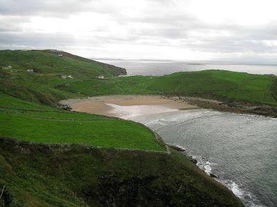
Tide was luckily out when we inspected the tip of the head. Our b & b was on the peninsula on the right of the photograph below.


No comments:
Post a Comment